Towering Cumulus Clouds: A Guide for Aviators
Towering cumulus clouds are a familiar sight to aviators, often signaling turbulence, thunderstorms, and significant weather changes. Understanding these clouds is crucial for flight safety and planning. In this article, we’ll explore the characteristics, formation, and impact of TCCs on aviation.
What Are TCCs?
Towering cumulus clouds, also known as “TCUs,” are large, vertically developed clouds. They are a more aggressive form of cumulus clouds, often marking the early stages of a thunderstorm. Their towering structure can rise thousands of feet into the atmosphere, indicating unstable air and strong updrafts.
Formation of Towering Cumulus Clouds
Towering cumulus clouds form when warm, moist air rises rapidly in an unstable atmosphere. As the air ascends, it cools and condenses, forming the cloud. When the air continues to rise, the cloud grows vertically, often reaching altitudes where the temperature drops significantly. This rapid vertical development is a hallmark of TCCs.
Impact on Aviation
- Turbulence: TCCs are notorious for causing turbulence. Pilots often experience strong updrafts and downdrafts within these clouds, making flights uncomfortable or even dangerous.
- Thunderstorms: TCUs are precursors to thunderstorms. When they grow large enough, they can develop into cumulonimbus clouds, leading to severe weather conditions, including lightning, hail, and heavy rain.
- Reduced Visibility: The dense nature of towering cumulus clouds can reduce visibility, making navigation difficult. In extreme cases, they may also contain embedded thunderstorms, which are hard to detect on radar.
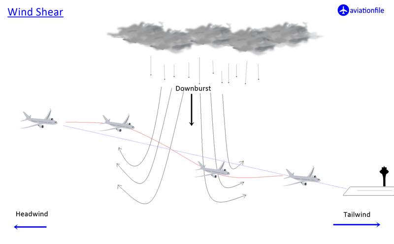
- Wind Shear: Rapid changes in wind speed and direction, known as wind shear, are common near TCUs. This can be hazardous during takeoff and landing, as it can affect the aircraft’s performance.
Avoidance and Safety Measures
- Flight Planning: Always check weather reports before departure. Towering cumulus clouds are often visible on radar and in METAR reports.
- Visual Identification: TCCs are easy to spot due to their towering, cauliflower-like structure. If possible, avoid flying through or near them.
- Altitude Consideration: Maintain a safe altitude to avoid the most intense turbulence. Flying over the cloud tops, if conditions allow, is often the best strategy.
- Communication: Keep in contact with air traffic control. They can provide real-time updates on weather conditions and suggest alternative routes.
Conclusion
TCCs are a significant concern for pilots. By understanding their formation, characteristics, and the potential hazards they pose, aviators can take proactive measures to ensure a safe flight. Always prioritize safety and remain vigilant when navigating areas with towering cumulus clouds.