The Minimum En-route Altitude (MEA)
En route refers to the phase of flight between departure and arrival, where aircraft maintain a stable altitude, follow designated airways, and navigate using Minimum En-route Altitudes (MEA) and Maximum En-route Altitudes (MEA) for safety and efficiency. Understanding this stage is crucial for ensuring reliable communication, navigation, and terrain clearance.
What is En Route Flight?
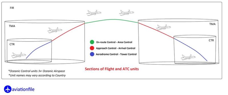
En route flight is the stage after takeoff and before descent. Pilots navigate along airways, predefined routes in the sky similar to highways. These airways are mapped using navigational aids like VOR (Very High-Frequency Omnidirectional Range) and GPS. Pilots must maintain specific altitudes, known as MEA and MRA, to ensure they can receive navigation signals and avoid obstacles.
The Role of Minimum En-route Altitude (MEA)
The Minimum En-route Altitude (MEA) is the lowest altitude an aircraft can safely fly while ensuring adequate terrain clearance and reception of navigational signals. MEA is vital in preventing collisions with mountainous terrain and ensuring that pilots remain connected to air traffic control. Flying below the MEA could result in signal loss or terrain interference, both of which are dangerous in low-visibility conditions.
Here are some of the related terms to MEA:
- Minimum Safe Altitude (MSA): The lowest altitude at which an aircraft can safely fly while maintaining obstacle clearance. The MSA is typically lower than the MEA.
- Minimum Obstruction Clearance Altitude (MOCA): The lowest altitude at which an aircraft can safely fly while maintaining obstacle clearance in the absence of radio navigation signals. The MOCA is typically lower than the MEA.
- Minimum Sector Altitude (MSA): The lowest altitude at which an aircraft can safely fly while maintaining obstacle clearance within a particular sector of airspace. The MSA is typically lower than the MEA.
MEA vs. Minimum Reception Altitude (MRA)
While MEA guarantees obstacle clearance and signal reception, the Minimum Reception Altitude (MRA) ensures only that the aircraft can receive navigational signals from ground stations. MEA encompasses a broader safety zone, protecting against terrain hazards and ensuring communication across long distances .
Challenges of En Route Navigation
Flying at en route altitudes poses unique challenges. Aircraft often cross regions with changing terrain, including mountains, valleys, and large bodies of water. Pilots must adjust their altitude to avoid obstacles and ensure reliable signal reception from navigational aids. Turbulence and weather patterns also influence altitude decisions during en route flight.
Terrain and Signal Considerations
When crossing mountainous regions, the MEA increases to maintain safe clearance. The closer an aircraft is to navigational aids, the more reliable the signals become. However, in remote regions, such as deserts or oceans, aircraft may have to rely on satellite-based navigation systems like GPS, which do not require proximity to ground stations .
Modern En Route Navigation Technologies
Advancements in technology have streamlined en route flight navigation. Today, Automatic Dependent Surveillance-Broadcast (ADS-B) and satellite navigation have reduced the need for ground-based signals. ADS-B allows aircraft to automatically broadcast their location, improving real-time tracking by air traffic controllers and other aircraft .
The Future of En Route Navigation
The future of en route navigation lies in satellite-based systems like the Global Navigation Satellite System (GNSS), which allows for global coverage without dependence on ground-based navigational aids. This transition reduces limitations imposed by terrain and increases efficiency for aircraft routing.
Conclusion
Understanding en route aviation is essential for ensuring safe and efficient flight operations. Maintaining correct altitudes through MEA and MRA keeps flights on course and out of harm’s way. With modern technologies like ADS-B and GNSS, the future of en route navigation looks increasingly reliable and precise, benefiting both pilots and air traffic controllers.
References
- Federal Aviation Administration (FAA). “Aeronautical Information Manual (AIM).”
FAA.gov - International Civil Aviation Organization (ICAO). “Navigation in Aviation.”
ICAO.int - Jeppesen. “En Route Flight and Altitudes.”
Jeppesen.com
