Navigation Aids (VOR, DME, NDB…)
Have you ever wondered how aircrafts (planes, helicopters…) find their way during flight? You can imagine that in the early years of aviation, pilots were more on their own with very limited aids in the air. A compass and a map that is doubtfull how detailed it is were the only materials to aid the flight. Today, there are very advanced direction finding, distance determination, approach/landing devices, systems and facilities. Aircraft position in the air is determined with radars and satellite-based systems (navigation aids). With new technology aircraft and systems, you can fly and land/take off even in completely overcast weather and difficult meteorological conditions.
Let’s first make a brief definition of navigation. Navigation in aviation is the process of taking the plane from one place to another with planning, position, direction, time and distance solutions. It includes planning, takeoff, climb, cruize flight, descent and landing stages. During navigation, devices installed on aircraft receive position, distance, heading, height, all information from the devices (navigation aids) on the ground and/or satellite. Direction/distance purpose devices located on the ground are NDB, DME, VOR. Landing facilitators are ILS and MLS and visual aids (such as runway lights). Radars, on the other hand, have different features, especially determining the location/distance in the air.
Let us explain the devices on the ground in order.
NDB (Non-Directional Radio Beacon)
Ground radio transmitter station that broadcasts at low or medium frequencies, which is not very sensitive, in order to find a heading. Aircraft equipped with the appropriate equipment determine their air conditions according to these signals.
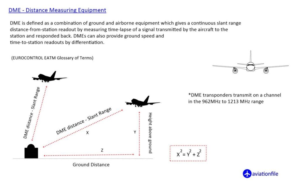
DME (Distance Measurement Equipment)
It works with the “pulse waves” system sent from the ground station. It does not provide direction information, only the distance to the station is obtained.
VOR (VHF Omni-Directional Range)
The VOR station produces 360 linear lines called radial at one degree intervals around itself. VOR information received on the plane gives the pilot radial information during flight. The transmitter broadcasting in all directions in the VHF band informs the user of its position according to the selected radio. VOR devices are also used in determining airport locations. There are VOR types such as NVOR (Normal VOR), TVOR (Terminal VOR) and DVOR (Doppler VOR).
If the aircraft is capable of operating with these devices, it can safely fly from one airport to another by using these devices. However, there are many more rules and devices to ensure the required flight safety. For example, devices designed to prevent aircraft from colliding in the air, separation criterias between aircraft, controllers (ATC) regulating air traffic in controlled airspaces and their directions / instructions and radar / satellite based systems.
Our plane took off from one airport, approached to another airport with the help of navigation aids (and/or radar-satellite systems mentioned above) and it is time to land. If the weather is clear, you can also land visually. If the visibility is low, weather is foggy, (meteorological conditions are not suitable for visual approach) you cannot see the runway clearly, and the visuals (lighting) on the runway is insufficient for landing, then you need an instrument landing system. This system is called ILS.
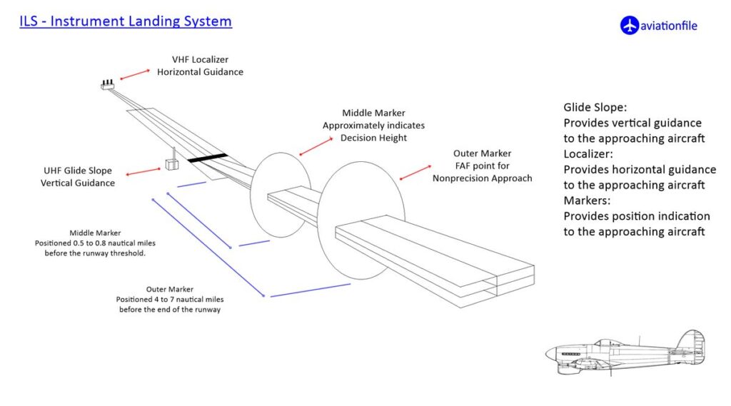
Instrument Landing System – ILS
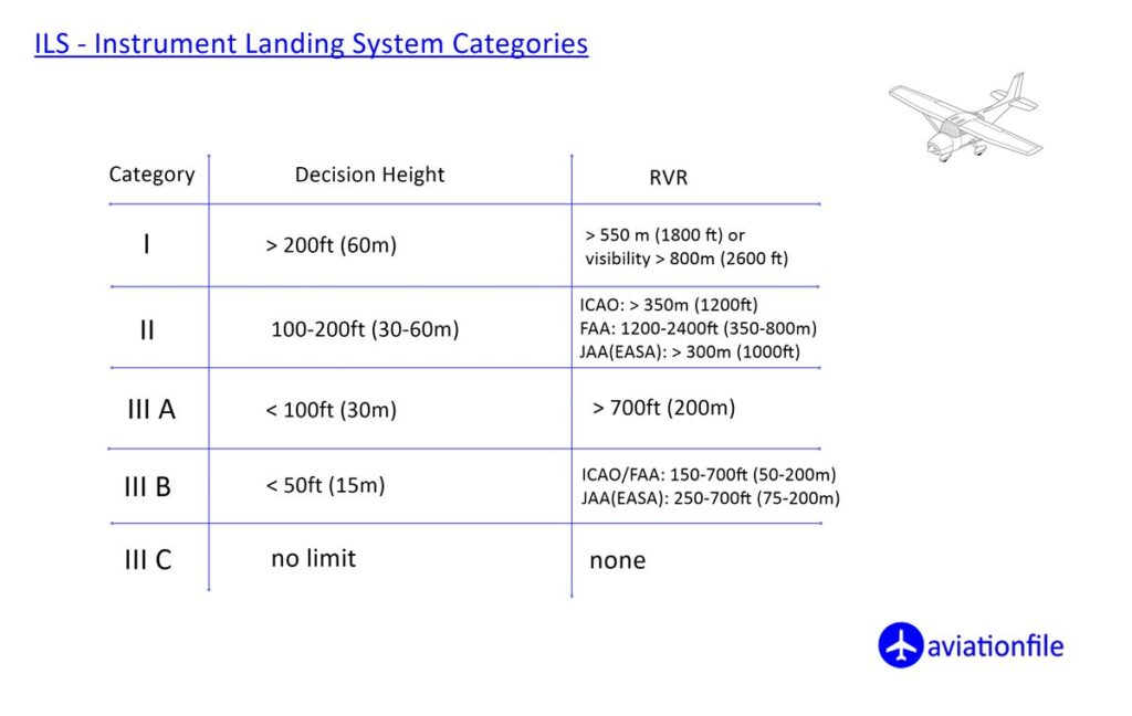
ILS is a ground system located at the runways at airports that contributes to the approach-landing of aircraft with horizontal-vertical status information. It consists of a combination of Localizer (LLZ), Glide Path (glide slope) and Marker (locating on the approach line; outer-middle-interior) devices and approach lights. It takes the plane into a cone from apprx 12 miles away and brings it closer to the runway at the appropriate inclination and height. ILS systems work in 3 categories according to the sensitivity they provide.
(See the figure for ILS categories)
MLS (Microwave Landing System)
It is fair to say that MLS is an improved version of the ILS system. The sensitive and critical area (affected by external factors) is much less needed and less affected by the construction around the runway. However, it provides a more precise approach / additional advantages. On the other hand, it could not find widespread use as satellite systems came into play.
Today, ILS devices, which are the safest approach system for landings, are systems that are likely to be affected by environmental constructions and other radio frequencies. A flat, unobstructed terrain is required for installation. There should be no natural obstacles (hills, trees) and buildings above the determined heights around it. For this reason, even if desired, it cannot be installed in every airport as a whole system.
TACAN (Tactical Air Navigation)
Military aircraft rely on a radio navigation system called TACAN (Tactical Air Navigation) for precise navigation. TACAN provides direction and distance information for military aircraft. A DME receiver can receive the signals sent by the TACAN station and benefit from distance information.
ADF (Automatic Direction Finder)
It is a navigation aid that provides direction finding opportunity depending on the ground stations broadcasting to aircrafts. There are two types of ground stations, NDB (Non Directional Beacon) and L (locator).
Operating in LF and MF band, this system shows the direction of the station according to the position of the aircraft, by means of the indicators on the aircraft.
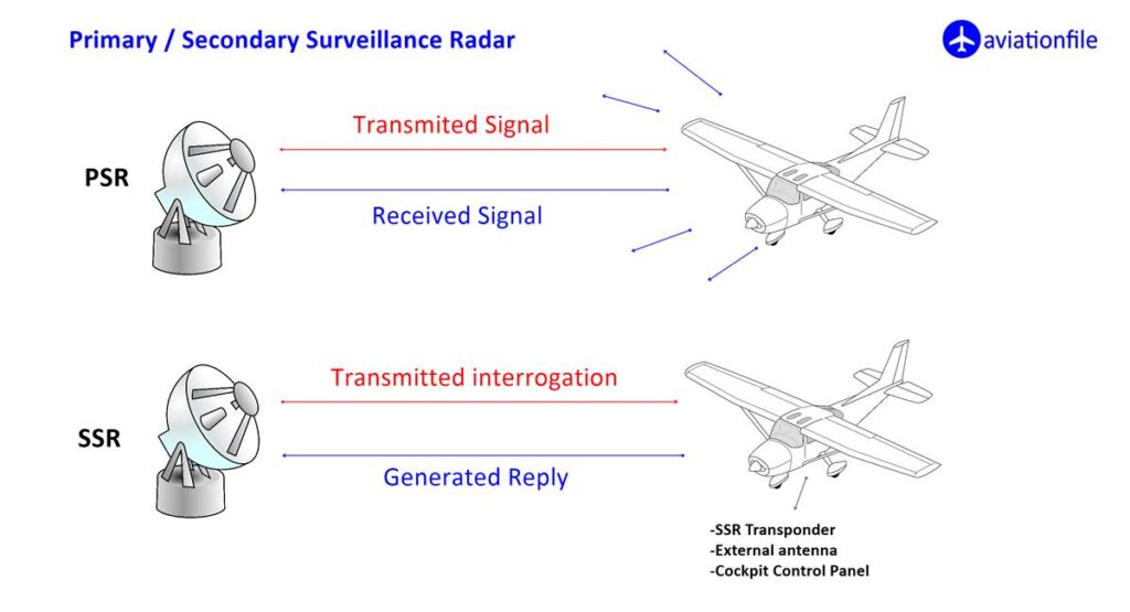
RADAR (Radio Detection and Ranging)
Radars (Radio Detection and Ranging), which are indispensable in today’s aviation, are devices that detect distant objects with microwave broadcasts. They broadcast at a speed of approximately 300 thousand kilometers per second. The location of the object (plane) is determined from the waves reflected back by hitting an object – in the context of the passage of time. Primary
(PSR) Radar works only as a ground station, detecting an object in the air. Secondary (SSR) radar works with the ground station and the transponder device installed on the aircraft, and mutual information exchange and information about the aircraft (identity, altitude, direction) appear on the radar screen. Air traffic controllers regulate the air traffic according to this information and give the necessary instructions to the aircraft (pilots). (For more detailed information about PSR and SSR radar systems click)
CPDLC (Controller-Pilot Data-Link Communications)
It is an air-ground communication system between the pilot and the controller. Provides communication in the form of a message as a supplement to traditional voice communication. Developers designed CPDLC to boost safety and efficiency in Air Traffic Management.
As can be seen, today’s technology supports us with very sensitive devices and systems for the take-off, level flight and landing stages of aircraft. Therefore, air transportation is the safest mode of transportation, and it will continue to be like this.